Mount Everest base camp 2023
24th January 2023
Mount Everest is the world's highest mountain, located at an elevation of 8,849 m above sea level. Numerous climbers, including expert mountaineers, are attracted to Mount Everest. There are two primary ascent routes: one enters Nepal from the southeast, also referred to as the "normal route," and the other enters Tibet from the north. On this tour, you get to see Mount Everest up close and personal from Kala Patthar, also known as the "black rock," at a perfect viewing distance. It's an amazing feeling to see the enormous Everest and take in its inspiring majesty.
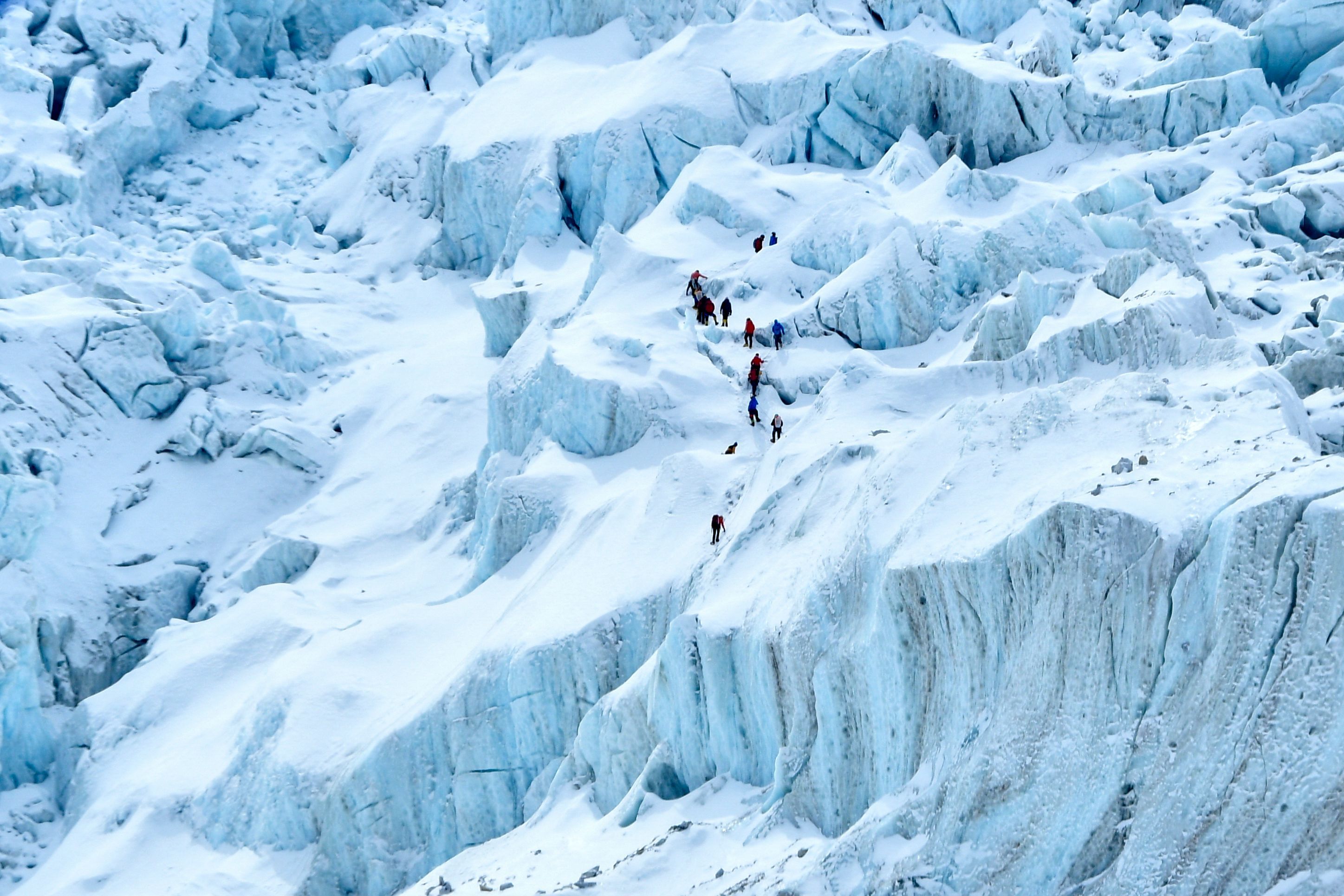
Mount Everest base camp trek is the best package for trekkers to explore the majestic view of Everest closely along with experiencing the Nepali culture and tradition. Mt. Everest is the trek's most attractive feature, but other well-known peaks like Mt. Ama Dablam, Mt. Lhotse, Mt. Nuptse, Mt. Lobuche, Mt. Tawache, etc. that are nearby and also soar to the skies could provide you with additional visual stimulation. The best way to travel to Mount Everest's base camp is during the Everest Base Camp Trek. Due to Mount Everest's immense popularity, the Everest base camp trip, located in the Sagarmatha National Park's Solukhumbu district, is the most well-liked trek among hikers. The walking tour ranks highly on explorers' must-do lists from all around the world. It enables visitors to see high altitudes, uncharted territory, ridges, steep slopes, woodland areas and settlements, terraces and farmlands, etc.
Mountain climbers frequently participate in treks that include climbing Mount Everest. It is, however, a difficult prospect. A guarantee of good health, equipment, and a qualified Nepalese guide are all necessary for the ascent of Everest, in addition to extensive prior climbing expertise. The mountain's snow and ice produce dangerous dangers like avalanches, and the inclement weather limits the climbing season. However, the altitude poses possibly the greatest threat. Most climbers use the bottled oxygen they bring with them because they aren't used to the high altitude and low oxygen levels. Because of this, the Everest region over 8,000 meters (26,000 feet) in height is referred to as the "death zone." Altitude sickness is the most common factor which affects the climbers during the trek.
Where is Mount Everest located?
Mount Everest, is situated between Nepal and China. According to a study carried out in 2005 by the China National Surveying and Mapping Administration, Everest has precisely located at 27° 59' North latitude and 86° 55' East longitude. Mount Everest, the highest mountain in the world, rises 8848 meters (29,029 feet) above sea level. China confirmed this Everest elevation in a survey it conducted in 1975 after Nepal and China first recognized it formally in 1955.
When Kangchenjunga (8,582 meters) was regarded as the highest peak in the world in the past, Mt. Everest did not have an official name among the local population. Mountain XV was designated as the highest peak in the globe by the British Survey team while doing their survey. Peak XV was declared the highest peak in the world by British surveyor Andrew Waugh, who gave it the name "Mt. Everest" in honor of his predecessor, Sir George Everest. Mount Everest's summit is on the Nepalese side, although its body is located in both nations (Nepal and China). On Mount Everest, there are two places. The location is in the Xigaze region of Tingri County, on the Tibetan side. The Sagarmatha National Park in the Solukhumbu area is where Nepal's side is situated. In many different languages, Everest goes by many different names.
What is Mount Everest's new height?
There is a discussion concerning Mount Everest's exact elevation because of variations in snow level, gravity departure, and light refraction, among other things. Everest maintained its height for the majority of the years at a distance from the sea of 8848 meters. In 1954, the Indian Survey measured the height of the mountain, which was this. The exact height of Everest has been measured using a variety of equipment and methods over the course of the past 200 years, as technology has advanced quickly from the 18th to the 21st centuries. In relation to the precise height of Everest, each study came to a different conclusion.
However, there has been much debate throughout the years over this spectacular peak's elevation. China and Nepal both recently published their measurements in a joint commission, and it is now at an acceptable height. Mount Everest's prior accepted altitude was 8848 meters (29,029 ft). The height of Everest is said to have increased more than before as a result of the movement of tectonic plates. Mount Everest is the highest point on Earth, rising 8,849 meters (29,032 ft) above sea level. The stated altitude is 8848.86 meters (29,031 feet). Geologists measure the height of the Himalayan mountain summit in relation to sea level.
How did Mount Everest form?
Rocks made up of solid rock slabs that make up our planet's cracked outer shell, known as tectonic plates, slowly moved to this unexpected location, about 30,000 feet above sea level. These plates are constantly jostling for position, which shapes the variety of surface features. Valleys are formed in the ground as the plates separate in some locations. In some of them, they run into each other and push mountains upward. Tens of millions of years ago, the Indian and Eurasian tectonic plates collided, creating Mount Everest, which now stands at the boundary between Tibet and Nepal. A mountain range known as the Himalayas was raised along a 1,500-mile stretch after the crash destroyed the earth. The plates still push each other, and Mount Everest gains height every year.
Why does Mount Everest keep changing its height?
The two continental plates are still colliding, and India is moving 5 cm northward annually, pushing Everest up 4 mm. You would ultimately run out of your tectonic forces, and then it would stop developing, according to Rachel Headley, an associate professor of geosciences at the University of Wisconsin. The plate that makes up the majority of India started to move northward
toward the plate that makes up the majority of Asia about 50 million years ago. The two plates clashed and pushed the Earth's crust upward during this collision, resulting in the formation of the Himalayan range. The two plates are still colliding, and it is driving the Himalayan range to rise higher and higher every year.
The Himalayan range's crust is being pushed upward by the Indian plate, which is still migrating toward the north. The mountains are rising higher as a result of this pressure. There is general agreement among scientists that the earth's mantle will cool to the point where the tectonic shift stops. Furthermore, if Everest does continue to rise without interruption, it will eventually get to a point where it is so steep and unstable that huge sections start to fall off.
Recent From Blogs
28th October 2025

25th October 2025
24th October 2025
18th October 2025

14th October 2025

12th October 2025
10th October 2025

7th October 2025